Eclipses have always fascinated me. My first recollection of a solar eclipse doesn’t come from witnessing one, but rather from a movie. As a child Saturdays meant watching cartoons in the morning then running around outside until dinner, except when it rained. On rainy days my siblings and I would do our best to entertain ourselves inside, which invariably meant watching TV.
We only had one TV in the house so we had to watch whatever my dad wanted. Our best bet would be old Abbott & Costello or Laurel & Hardy movies or maybe some cool sports on ABC’s Wide World of Sports. My father was a fan of old movies, too, but his tastes were out there for young children. We were just as likely to get get light-hearted romance musical as we were to get adventure or comedy. On one particular Saturday, we experienced the rare combination of all three: Bing Crosby’s 1949 take on Mark Twain’s A Connecticut Yankee in King Arthur’s Court.
My dad has always had a soft spot for a Bing Crosby flick. Fortunately for us this was no Bell’s of Saint Mary’s or White Christmas (two movies I now appreciate much more than when I was a child). It had knights, castles, Merlin, and just the right amount of comedy to appeal to me and my siblings. So what’s the connection to eclipses? In one scene Bing Crosby’s character (a mechanic from early 20th century Connecticut) uses his knowledge of a pending eclipse to save his neck. For whatever reason, that scene stuck with me.
Eclipse Atlas
While doing some research on eclipses, to potentially incorporate them in one of my upcoming books, I stumbled across NASA’s World Atlas of Solar Eclipses. The site maps 5,000 years of solar eclipses. Every solar eclipse from 2,000 BC through 3,000 AD. The maps cover twenty year increments and include the paths and types of eclipses. To capture all of the eclipses through 2040 I needed use two maps.
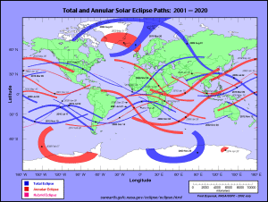
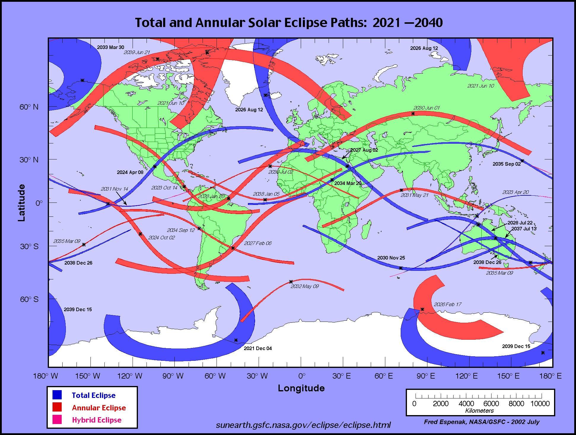
While most of you probably now this, but widths of the paths vary for two reasons. First, eclipses are caused by the position of the earth, sun, and moon relative to each other. That geometry varies, which in turn impacts the area effected by the eclipse. The second reason is also related to geometry. The earth is roughly spherical in shape and projecting it onto a flat surface produces distortions. I’m not sure if these maps use the Mercator projection or something similar, but they clearly enlarge features near the poles. If you’re new to this blog I wrote an earlier post about projections here.
FWIW I did eventually see an eclipse in person. In May 1984 while working as a life guard in northern Virginia, Tina Robb and I made a pinhole camera to look at an annular eclipse, which is when the moon appears smaller than the sun and a bright ring surrounds the moon.
As always thanks for reading.
Armen
PS According to the NASA maps there was a total eclipse in sixth century England, but it was in 536, which according to Wikipedia is 8 years after Bing Crosby’s character traveled back in time.
Note to pay the bills: As you may have noticed this website does not contain advertisements. Funding comes solely from sales of my books. If you’re interested in learning more about the award winning Misaligned series check out a summary of the series here or find links to purchase books here. Thanks for your support.